
Hurricane Irene closed in on the U.S. Atlantic coast on Friday, triggering emergency preparations that included unprecedented evacuations and mass transit shutdowns in New York City as the menacing storm approached.
As Irene careened north, rain and tropical storm force winds and ferocious surf began pummeling the North Carolina coast. “The core of the hurricane will approach the coast of North Carolina tonight and pass near or over the North Carolina coast on Saturday,” the U.S. National Hurricane Center said in an advisory on Friday evening.
Washington and states from the Carolinas through Maine declared emergencies due to Irene, a nearly 600 mile (960 km)-wide hurricane that put 55 million Americans on the eastern seaboard on alert and that experts say could cause billions of dollars in damages.
President Barack Obama said the impact of the storm, an unusually large storm, could be “extremely dangerous and costly” for a nation that still remembers destructive Hurricane Katrina in 2005. “All indications point to this being a historic hurricane,” Obama said.
Hundreds of thousands of residents and vacationers were evacuating from Irene’s path.
A quarter of a million New Yorkers were ordered to leave homes in low-lying areas, including the financial district surrounding Wall Street in Manhattan, as authorities prepared for dangerous storm surge and flooding on Sunday in the city and farther east on Long Island.
Some New York hospitals in flood-prone areas were already evacuating patients, and New York’s mass transit system, which carries 8.5 million people on weekdays, was due to start shutting down around noon (1600 GMT) on Saturday.
“We’ve never done a mandatory evacuation before and we wouldn’t be doing it now if we didn’t think this storm had the potential to be very serious,” Mayor Michael Bloomberg told a news conference.
As U.S. authorities ramped up preparations to cope with a potential major natural disaster on the densely populated East Coast, U.S. airlines canceled more nearly 7,000 flights and moved airplanes out of Irene’s path.
Officials were taking every precaution with Irene because they remember all too well how Katrina swamped New Orleans, killing up to 1,800 people and causing $80 billion in damages.
Defense Secretary Leon Panetta said the military stood ready to aid in the response to Irene, with more than 100,000 National Guard forces available if needed in eastern states.
Coastal communities stocked up on food and water and tried to secure homes, vehicles and boats. Cities, ports, hospitals, oil refineries and nuclear plants activated emergency plans.
The earliest edges of Irene began to knock down trees, caused localized flooding and had knocked out power to 7,600 residents of Wilmington, North Carolina by Friday night.
People huddling in a shelter at a local school said they feared the storm’s potential impact but were reluctant to evacuate entirely.
“We were going to go to Charlotte, but we were told we might not be able to get back if there was a lot of damage,” said Chastity May, 34, as she watched over her 4-year-old son.
Some were looking to capitalize on the approaching storm.
Greg Bayly, 52, and Scott Olden, 24, were selling generators out of a rented cargo truck along a busy Wilmington street that leads out to nearby beaches. Bayly said the pair could process credit cards to complete purchases, despite the rapidly deteriorating weather conditions.
U.S. federal and state leaders, from Obama downward, urged the millions of Americans in the hurricane’s path to prepare and to heed evacuation orders if they received them.
WIND FIELD “HUGE”
Irene weakened early on Friday to a Category 2 hurricane from a 3 on the five-step Saffir-Simpson scale, but it was still carrying winds of up to 100 miles per hour (155 kph).
It was expected to remain a hurricane as it sweeps up the mid-Atlantic coast over the weekend. The Miami-based hurricane center said it could dip below hurricane strength before reaching New England, but its impact would not vary much.
At 8 p.m. EDT (midnight GMT), Irene’s center was 235 miles (380 km) south-southwest of Cape Hatteras, North Carolina and churning north-northeast.
Irene, the first hurricane of the 2011 Atlantic season, has already caused as much as $1.1 billion in insured losses in the Caribbean this week, catastrophe modeling company AIR Worldwide said, with more losses expected to come.
The hurricane center said hurricane force winds extended outward up to 90 miles (150 km) from Irene’s center, while tropical storm force winds extended out up to 290 miles (465 km), giving the storm a vast wind field width of nearly 600 miles (960 km).
“The wind field is huge,” NHC Director Bill Read told Reuters Insider.
In earlier comments, Read said Irene, which will be the first significant hurricane to affect the populous U.S. Northeast in decades, would lash the eastern seaboard with tropical storm-force winds and a “huge swath of rain” from the Carolinas to New England.
“WATCHING THAT BIG WHITE SWIRL”
Wall Street firms scrambled to raise cash into early next week in case Irene caused major disruption in trading.
Traders were “watching that big white swirl” on their television sets, said Guy LeBas, chief fixed income strategist at Janney Montgomery Scott in Philadelphia.
Northeast oil, natural gas and power facilities also made preparations.
Brent crude oil futures rose in choppy trading on Friday as the storm approached and traders weighed comments by Federal Reserve Chairman Ben Bernanke on the economy.
Benedict Willis III, director of floor operations for investment banking boutique Sunrise Securities, said the New York Stock Exchange had a responsibility to open on Monday after the storm passes because millions of investors will be relying on it for stock prices.
“But if the waters rise this high,” he said, gesturing at the buzzing trading floor, “then it’s a bigger problem than I can handle. My name’s not Noah.”
Irene will be the first hurricane to hit the U.S. mainland since Ike pounded Texas in 2008.
In Washington, Irene forced the postponement of Sunday’s dedication ceremony for the new memorial honoring civil rights leader Martin Luther King Jr. Tens of thousands of people, including the president, had been expected to attend.
Flooding from Irene killed at least one person in Puerto Rico and two in Dominican Republic. The storm knocked out power in the Bahamian capital, Nassau, and blocked roads with trees.
Reuters

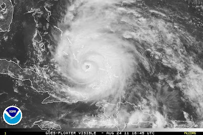
Here's the Tuesday morning visible satellite image of Category Two Hurricane Irene with maximum sustained winds of 100 mph, as viewed from space:

Hurricane Irene did not strengthen overnight, but is becoming better organized as it moves away from the Dominican Republic and Haiti.

Irene's track through the Bahamas looks likely based on good consistency between forecast models.

Sea surface temperatures are very warm and highly favorable for intensification of Irene as it passes into and over the Bahamas. By Wednesday, Irene should have strengthened into a "major" hurricane at Category Three strength of winds at least 111 mph or stronger. While continuing to pass over these warm waters east of Florida, this intensity should be maintained.

An upper-level wave from the U.S. should encourage Irene to take a more northerly shift late Saturday into early Sunday, aiming Irene for the southern North Carolina coast:

It is crucial as we look into this weekend to not pay as close attention to the little red hurricane icon on the map, but rather to the white highlighted area of potential impact in our region:

Speaking of the "area of impact," here are some of the possible weather impacts we may experience in central Virginia:

Here is the model spread for our region of the Mid-Atlantic Coast (the lines represent the various forecast centers of the storm's track):

Irene should continue as an extremely strong cyclone as it transitions to an extra-tropical system in New England Sunday-Monday next week:

Stay with CBS6, we'll keep you ahead of the storm.
--Meteorologist Carrie Rose

Want to see what a major hurricane looks like chewing through a nation of 29 islands, 661 cays, and 2,387 islets? NASA's TRMM satellite has the goods, displaying Hurricane Irene—white tendrils of tropical fury stretching hundreds of miles north and south of the island chain—as it whips over Crooked Island in the Bahamas.
TRMM, which stands for Tropical Rainfall Measuring Mission, also has its eye on Irene's moisture output. According to NASA, the satellite's been able to track rainfall rates, cloud heights and "hot towering clouds that act as hurricane heat engines."

Beautiful tall waves - we very seldom get these here - lots of wind and many surfers enjoying themselves! This direction is due east, and the dark clouds on the horizon is Hurricane Irene, just leaving the Bahamas. It was quite beautiful down at the beach; lots of people taking it all in, very windy but warm.
CURRENT STATUS AS OF 5PM ADVISORY
Visit World In Magazine for Daily Updated Hairstyles Collection


